Open data has become a significant resource in this sector, supplementing business intelligence, market and economic research, and consulting services. The most used types of open data include economic, demographic and social, and legal.
Many organizations use open data to provide financial, economic, industry or legal data and intelligence. These organizations facilitate access to this information, as well as develop visualizations and additional analysis for their clients. They help companies manage risks, identify market and investment opportunities, conduct trend and predictive analysis and develop forecasts to support their clients’ decision-making.
Those that provide legal intelligence use intellectual property data such as patents and trademarks to attorneys, researchers, and inventors. Still others collect, code and publish up-to-date statutory and regulatory legal information.
Types of Data Most Used
Size, Type & Founding Year
How Organizations Use Open Data

Use Cases

Template
Country: United States
Impact: Farmers benefit from tools for better crop management and to measure environmental factors
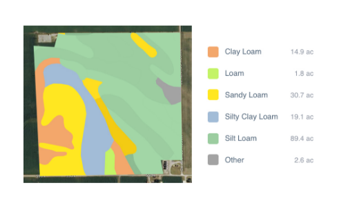
Data Used: Rainfall data from US National Oceanic and Atmospheric Administration’s (NOAA) National Climatic Data Center, soil data from US Department of Agriculture
FarmLogs provides farmers with a free software and mobile application to map and analyze crop yields and environmental conditions for crop growth through government data. Their Farmlogs free Standard includes several features: Field Mapping, Scouting and Notes, Activity Tracking, Rainfall Tracking, GDD Accumulation, Soil Composition Maps, Growth Stage Analysis, Yield Maps, Input Planning. They also empower farmers to coordinate with the government to request data for their lands. On their website, FarmLogs details instructions on how to contact the US Department of Agriculture's Farm Service Agency for field boundary data. Upon receipt, FarmLogs interprets the data and creates field boundaries on mapping systems for farmers to demarcate their lands.