Organizations use open data as a basis for culture and tourism guides for visitors and to calculate expected sales. The main types of data used include arts & culture, demographic and social, and tourism.
Tourism organizations use open cultural data to reach new audiences by mapping, providing information on, and marketing local sites and events. They use the data to promote events to specific audiences, and allow visitors to navigate the various options available to them.
A number of organizations also use data on weather predictions, consumer, tourism and economic data for planning purposes, in order to be prepared for and accommodate differing numbers of visitors throughout the year.
Types of Data Most Used
Size, Type & Founding Year
How Organizations Use Open Data

Use Cases

Template
Country: United States
Impact: Farmers benefit from tools for better crop management and to measure environmental factors
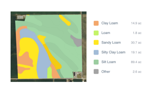
Data Used: Rainfall data from US National Oceanic and Atmospheric Administration’s (NOAA) National Climatic Data Center, soil data from US Department of Agriculture
FarmLogs provides farmers with a free software and mobile application to map and analyze crop yields and environmental conditions for crop growth through government data. Their Farmlogs free Standard includes several features: Field Mapping, Scouting and Notes, Activity Tracking, Rainfall Tracking, GDD Accumulation, Soil Composition Maps, Growth Stage Analysis, Yield Maps, Input Planning. They also empower farmers to coordinate with the government to request data for their lands. On their website, FarmLogs details instructions on how to contact the US Department of Agriculture's Farm Service Agency for field boundary data. Upon receipt, FarmLogs interprets the data and creates field boundaries on mapping systems for farmers to demarcate their lands.