This region comprises the second largest number of organizations using open data, after North America. It includes many commercial enterprises and an active developer community. Many are SMEs.
Organizations in Europe and Central Asia use open data across all sectors, with the most in the IT and geospatial, governance, business research and consulting sectors. There is also a greater percentage of open data use by media and communications organizations in Europe and Central Asia than in any other region. The information most used in the region includes geospatial, government operations, transportation, demographic and social data and statistics.
Overall, both established and new organizations are using open data in the region. Over two thirds are for-profit, and almost half of the organizations are small organizations with ten or fewer employees. The majority of commercial enterprises are located in higher income countries. In low and middle income countries (Moldova, Georgia, Ukraine, Kosovo), the organizations identified are mostly nonprofits focusing on using open data to promote economic and social development and for advocacy.
Size, Type & Founding Year
Sectors Using Open Data

Use Cases

Template
Country: United States
Impact: Farmers benefit from tools for better crop management and to measure environmental factors
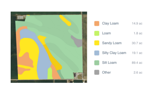
Data Used: Rainfall data from US National Oceanic and Atmospheric Administration’s (NOAA) National Climatic Data Center, soil data from US Department of Agriculture
FarmLogs provides farmers with a free software and mobile application to map and analyze crop yields and environmental conditions for crop growth through government data. Their Farmlogs free Standard includes several features: Field Mapping, Scouting and Notes, Activity Tracking, Rainfall Tracking, GDD Accumulation, Soil Composition Maps, Growth Stage Analysis, Yield Maps, Input Planning. They also empower farmers to coordinate with the government to request data for their lands. On their website, FarmLogs details instructions on how to contact the US Department of Agriculture's Farm Service Agency for field boundary data. Upon receipt, FarmLogs interprets the data and creates field boundaries on mapping systems for farmers to demarcate their lands.