A large number of organizations worldwide use open data in this sector to improve governance. They are primarily nonprofits that use open data to monitor budgets, evaluate performance, and conduct issue-based advocacy. The most used types open data include government operations, legal, health, and demographic and social.
From Nigeria to Ukraine, organizations use data on budgets and spending to expose and prevent mismanagement and corruption. An increasing number are monitoring government contracting and procurement as well. Other good-governance organizations use open demographic and voting information to improve voter registration and representation, as well as to provide information on polling and candidates.
Open data is also a critical tool for issue-based advocacy and citizen engagement. For example, organizations use spending and performance information on health or education to reveal and deter corruption that can keep institutions from getting the funds they’re entitled to.
Types of Data Most Used
Size, Type & Founding Year
How Organizations Use Open Data

Use Cases

Template
Country: United States
Impact: Farmers benefit from tools for better crop management and to measure environmental factors
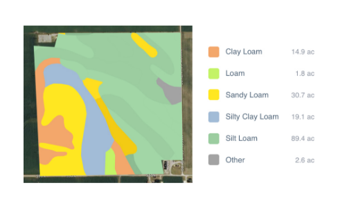
Data Used: Rainfall data from US National Oceanic and Atmospheric Administration’s (NOAA) National Climatic Data Center, soil data from US Department of Agriculture
FarmLogs provides farmers with a free software and mobile application to map and analyze crop yields and environmental conditions for crop growth through government data. Their Farmlogs free Standard includes several features: Field Mapping, Scouting and Notes, Activity Tracking, Rainfall Tracking, GDD Accumulation, Soil Composition Maps, Growth Stage Analysis, Yield Maps, Input Planning. They also empower farmers to coordinate with the government to request data for their lands. On their website, FarmLogs details instructions on how to contact the US Department of Agriculture's Farm Service Agency for field boundary data. Upon receipt, FarmLogs interprets the data and creates field boundaries on mapping systems for farmers to demarcate their lands.