Open data has fueled major advances for improved health outcomes, ranging from increased access to care to informing medical research. Organizations in this sector rely on open health, geospatial, demographic and social, as well as scientific research data.
Internationally, organizations are using open data to help consumers find local healthcare services and providers to meet their needs. Many draw on government data to provide citizens with information on doctors, specialists, and hospitals via web and mobile applications. It is also being applied to help make medication more accessible and affordable. For instance, organizations use geospatial data and government data on pharmacy locations and prices to help consumers find the medicines they need and compare prices.
Open data is used also to evaluate health outcomes, develop more effective treatments, and predict disease outbreaks. For instance, researchers use health data, demographic and social statistics, environmental and geospatial data, and more, to conduct epidemiological studies, predict and monitor disease outbreaks, and target responses.
Types of Data Most Used
Size, Type & Founding Year
How Organizations Use Open Data

Use Cases

Template
Country: United States
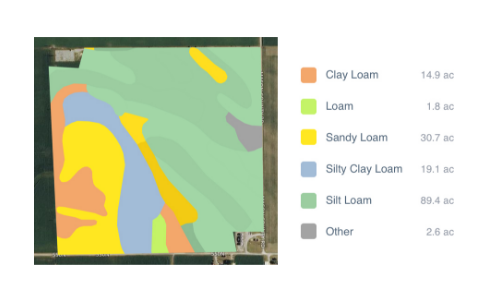
Impact: Farmers benefit from tools for better crop management and to measure environmental factors
Data Used: Rainfall data from US National Oceanic and Atmospheric Administration’s (NOAA) National Climatic Data Center, soil data from US Department of Agriculture
FarmLogs provides farmers with a free software and mobile application to map and analyze crop yields and environmental conditions for crop growth through government data. Their Farmlogs free Standard includes several features: Field Mapping, Scouting and Notes, Activity Tracking, Rainfall Tracking, GDD Accumulation, Soil Composition Maps, Growth Stage Analysis, Yield Maps, Input Planning. They also empower farmers to coordinate with the government to request data for their lands. On their website, FarmLogs details instructions on how to contact the US Department of Agriculture's Farm Service Agency for field boundary data. Upon receipt, FarmLogs interprets the data and creates field boundaries on mapping systems for farmers to demarcate their lands.